📝 Paper Summary
Generative Recommendation
Spatial-Temporal Reasoning
Location-Based Services
ROS integrates geography into LLM reasoning via hierarchical spatial IDs and a three-stage mobility Chain-of-Thought aligned by spatial-guided reinforcement learning.
Core Problem
Existing LLM-based recommenders treat locations as arbitrary text tokens, failing to capture essential mobility patterns like distance feasibility, neighborhood continuity, and spatial hierarchy.
Why it matters:
- Standard models recommend geographically implausible POIs (e.g., jumping across cities instantly) because they lack distance awareness.
- Local services require high precision in spatial feasibility, which generic sequence modeling often ignores.
- Current methods use location as auxiliary features rather than a decision variable, preventing the model from actively reasoning about where a user can physically go.
Concrete Example:
A user visits a cafe in Manhattan. A standard LLM might suggest a highly correlated cafe in Brooklyn or a semantically similar gym in another state, ignoring that the user cannot travel that far instantly. ROS uses address constraints to prune these distant candidates.
Key Novelty
Reasoning Over Space (ROS)
- Represents POIs using a Hierarchical Spatial Semantic ID (SID) that combines coarse-to-fine S2 geometry with quantized semantic embeddings, making location explicitly compositional for the LLM.
- Enforces a 3-stage 'Mobility Chain-of-Thought' (Personality → Intent → Pruning) where the model explicitly filters candidates based on address and distance constraints.
- Aligns the model using Group Relative Policy Optimization (GRPO) with a composite reward function that penalizes physical distance and rewards hierarchical SID correctness.
Architecture
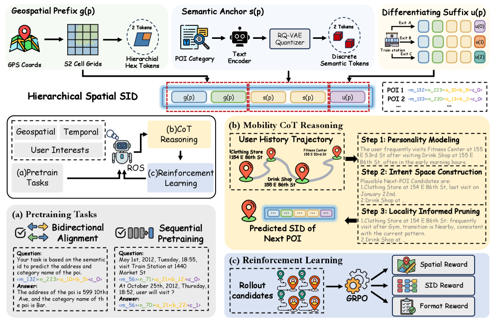
The overall ROS framework illustrating the construction of Hierarchical SIDs and the three-stage Mobility CoT reasoning process.
Evaluation Highlights
- Achieves over 10% relative gains in Hit Rate (HR@1) over strongest LLM-based baselines (CoAST, GA-LLM) on Foursquare-NYC and Foursquare-TKY datasets.
- Surpasses CoAST by +15.7% relative HR@1 on the Gowalla-CA benchmark.
- Outperforms larger 7B baselines using a smaller 4B backbone model, demonstrating that structured spatial reasoning is more efficient than pure scaling.
Breakthrough Assessment
8/10
Significantly advances generative recommendation by moving beyond 'location as token' to 'location as reasoning constraint,' with strong empirical gains using efficient models.